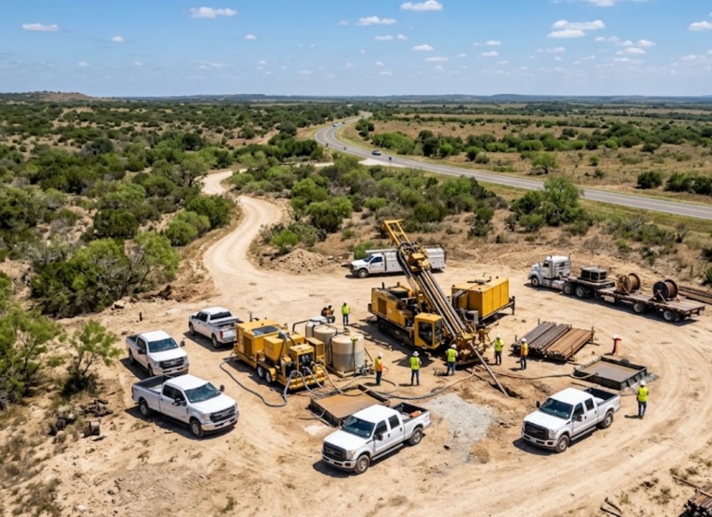
Switchgear feed under a Watson Road warehouse pad
Post-paving TI cannot trench a truck court to reach new switchgear. HDD ties manholes under asphalt with entry pits offset from dock striping.
Buckeye, AZ · Maricopa County
Steerable HDD beneath Verrado courtyards, Watson Road warehouse pads, and ADOT I-10 relocations — mud programs tuned for far West Valley caliche, SRP canal fill, and White Tank fringe boulder fields.
Horizontal directional drilling in Buckeye keeps sewer, water, and duct bank off the surface when a lateral fails under a Sundance gravel drive or a Tartesso courtyard wall — open-cut would mean rebuilding master-planned hardscape across lots that still back onto empty desert. GCs finishing TI on I-10 logistics pads and Watson Road retail steer conduit between vaults after paving is down, so truck courts and tenant access stay open while the bore crosses under asphalt.
Buckeye's fastest-growing corridors stack shallow utilities in the first few feet: APS secondary, SRP laterals, city water and sewer, warehouse-scale electric feeds, and carrier fiber along SR-85 and Watson Road. HDD here starts with Arizona 811, remark tickets where paint conflicts, and potholes before pits open — Directional Boring Arizona sizes spreads for Tartesso grading fill versus White Tank cobble, not a one-size West Valley recipe.
SR-85 truck volume and I-10 widening relocations layer ADOT MOT, SRP easement hold points, and warehouse shift windows on top of standard locate discipline. Night bores on Watson Road frontage are common when daytime lane closure would choke freight access to Buckeye's industrial belt.
Real Maricopa County angles — not generic statewide copy.
Post-paving TI cannot trench a truck court to reach new switchgear. HDD ties manholes under asphalt with entry pits offset from dock striping.
PVC failed under rock mulch and a courtyard wall — steerable shot from meter to cleanout saves pavers and desert landscaping open-cut would rip out.
ADOT widening queues multiple shallow utilities under state ROW. HDD shrinks lane closure footprint versus continuous trench; night MOT scoped before mobilization.
Tight ROW with APS and fiber congestion — cased segments where fence-line trenching would violate owner hold points on a live campus pad.
Buckeye HDD crews lock survey and valid 811 paint before steel enters ground — two business days minimum, longer when ADOT or SRP owns the easement. Entry pits are shored for caliche sidewalls and master-plan fill; mud weight climbs near SRP laterals and White Tank wash corridors. Pilot, ream, and pullback are watched for frac-out and buoyancy on long HDPE runs through desert alluvium.
Buckeye parcels mix caliche hardpan, desert wash alluvium, and master-planned grading fill — White Tank foothill cobble and boulder fields slow pilots without matched mud programs.
Most Buckeye bores hit caliche crust between 2 and 8 feet, then alluvial sand or compacted master-plan fill depending on parcel age. White Tank fringe and north Buckeye shots add cobble and fractured granite that slow penetration without correct tooling. Verrado and Sundance grading can hide old field irrigation structures that potholing catches before pits are sized. Shallow groundwater along SRP laterals and desert washes raises buoyancy risk on long HDPE pulls — we size ream stages for Buckeye fill, not a Goodyear copy-paste.
Far West Valley heat, spring dust, and monsoon outflows shape Buckeye bore schedules — White Tank wash runoff and afternoon lightning holds are planned into quotes.
Monsoon season from July through September softens wash-adjacent clay and can delay entry pits on north Buckeye parcels. Spring dust on exposed Verrado pads affects cage and fluid handling along Watson Road. Summer heat above 115°F slows morning startup on exposed sites but rarely stops work — we communicate when dry conditions matter for caliche-heavy pits rather than risk frac-outs toward SRP laterals.
City of Buckeye Development Services, Maricopa County ROW, ADOT District, SRP canal easements, and White Tank Mountain Regional Park coordination apply on many alignments.
Inside Buckeye city limits, street cuts, driveway removals, and wash-adjacent work may need Development Services permits. Maricopa County ROW rules apply on unincorporated pockets toward the Gila Bend fringe. ADOT controls I-10, SR-85, and state highway bores — expect traffic control plans and sometimes night-only windows on truck corridors. SRP canal easements add coordination beyond standard 811. Master-planned community parcels may add HOA and landscape bond review on pit placement.
Verrado pavers, Watson Road parking restoration, and HOA landscape bonds often cost more than the bore itself. HDD wins on SR-85 congestion and canal easements — raw acreage on Tartesso greenfield pads before paving may still pencil as open trench.
Footage, diameter, caliche versus rock, dewatering, traffic control, permit fees, utility density, and rig class — quoted as drivers, not a menu price.
You share plans or describe the problem; we confirm alignment, depth, access, and which trenchless method fits Arizona soils.
Arizona 811 ticket filed; two business days minimum before pits open unless your permit path differs. We pothole where marks conflict.
Bore plan, ADOT or city ROW permits, railroad agreements, and crossing engineering when the path leaves private property.
Compact spread for tight Scottsdale lots; larger HDD for I-17 or Loop 101 relocations — matched to length and diameter.
Steered pilot on design line, ream passes sized for your pipe or casing, fluid program tuned for caliche or decomposed granite.
HDPE fusion, steel casing, or multi-duct bundle pulled with tension and bend-radius monitoring.
Pressure test, mandrel, or survey records for owners, inspectors, and operators as spec requires.
Compact pits, replace gravel or hardscape per scope, leave 811 ticket and locate map in your project file.
Buckeye HDD pricing tracks length, diameter, caliche or boulder, shallow utility density, HOA restoration, and truck MOT — not a menu rate. A Verrado driveway lateral, a Watson Road duct bank, and an I-10 ADOT crossing mobilize different spreads. Send alignment and pipe size for a free estimate.
Yes — mud weight, tooling, and sometimes alignment revision handle caliche hardpan and foothill cobble on north infill. Wash-adjacent groundwater and monsoon saturation need extra planning on longer pulls.
Two business days minimum after 811 filing. Watson Road, SR-85, and I-10 corridors often need remark tickets and potholes at abandoned farm and irrigation lines.
Yes — daily far West Valley mobilization; city, county, and utility tap rules shift by address.
Often yes with offset pits and a steerable path — small tie-in cuts at meter or cleanout are flagged in the quote.
24/7 — Emergency dispatch statewide. Tell us entry, exit, pipe size, and county — a bore specialist calls back with cost drivers, not a flat rate.
Scope your alignment
Step 1 of 2 — path, pipe, and city first