Vault tie-in under a McCulloch Boulevard retail pad
Post-paving TI cannot trench across tenant parking to reach switchgear. HDD links manholes under asphalt with pits offset from striping.
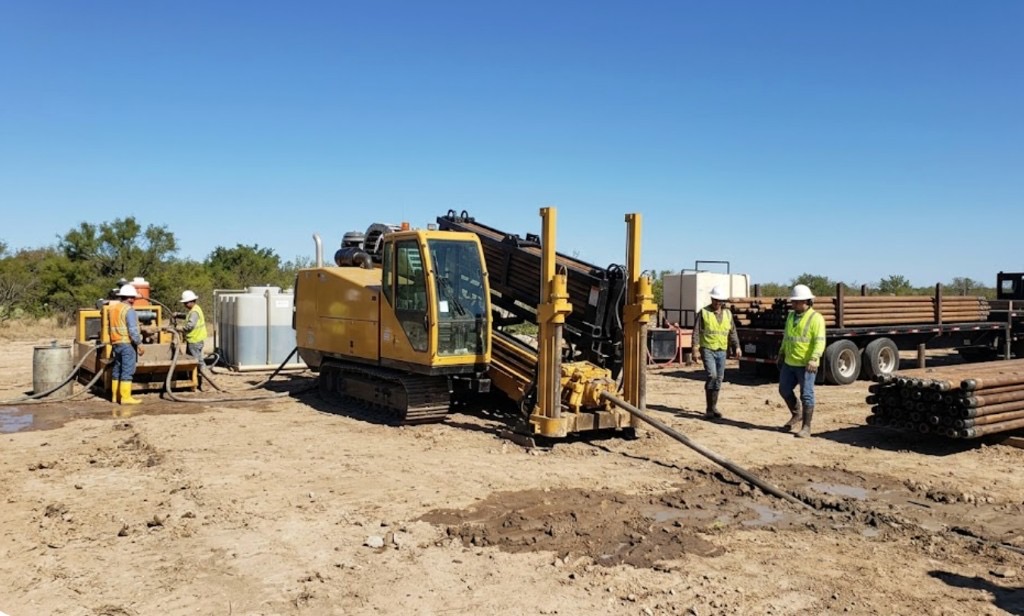
Lake Havasu City, AZ · Mohave County
Steerable HDD under Lake Havasu lakefront drives, McCulloch Boulevard retail pads, and Highway 95 relocations — mud and dewatering programs for Colorado River sand, Bridgewater Channel groundwater, and Mohave County granite cobble.
Horizontal directional drilling in Lake Havasu City is how Desert Hills and Havasu Riviera owners replace sewer and water lines under decomposed granite and courtyard walls without surrendering desert hardscape to open-cut restoration during peak tourist season. General contractors on lakefront marina TI and McCulloch Boulevard hospitality work pull duct bank between vaults after pavers are set — boat-ramp parking and channel-front access stay open while conduit crosses under the pad.
Lake Havasu's shallow utility stack — UniSource secondary, Southwest Gas, city water and sewer, irrigation laterals, and carrier fiber — means HDD starts with Arizona 811 and hand holes at paint conflicts before rig mobilization. Directional Boring Arizona matches spread size to river sand versus Mohave granite, not a generic Phoenix valley template.
Directional boring in Lake Havasu on Highway 95 and London Bridge Road frontage layers ADOT MOT, marina easement rules, and spring-break traffic control on standard locate discipline. Lakefront redevelopment along the Bridgewater Channel adds night-window bores when daytime traffic on McCulloch cannot stop.
Real Mohave County angles — not generic statewide copy.
Post-paving TI cannot trench across tenant parking to reach switchgear. HDD links manholes under asphalt with pits offset from striping.
Failed lateral under decomposed granite — steerable bore from meter to cleanout preserves hardscape open-cut would rebuild.
ADOT widening stacks relocations under state ROW. HDD narrows lane closure versus open trench; night windows scoped before booking.
Lakefront corridor ROW with shallow congestion and owner hold points — cased approaches where open cut would shut boat-ramp access.
Lake Havasu HDD crews confirm survey and locate paint — two business days minimum on 811, longer when ADOT or a marina district controls the easement. Pits are shored and dewatered for running sand near the Bridgewater Channel; mud weight rises on river-adjacent paths. Pilot, ream, and pullback are monitored for buoyancy on long HDPE pulls through Colorado River alluvium.
Lake Havasu City soils are Colorado River alluvium, decomposed granite, and compacted lakefront fill — high water table near the channel and river banks demands dewatering discipline absent on inland caliche jobs.
Most Lake Havasu City bores hit loose Colorado River sand and decomposed granite in the first few feet, then compacted lakefront grading or basalt cobble depending on parcel elevation. Channel-adjacent and river-bank shots carry high groundwater that collapses uncased entry pits without dewatering. Havasu Riviera master-plan fill can hide old marina drainage structures that potholing catches before pits are sized. We size ream stages for river alluvium and water table, not an inland Phoenix caliche template.
Lake Havasu's desert heat and summer monsoon surges shape bore schedules — Colorado River humidity pockets and afternoon lightning holds are planned into quotes.
Monsoon season from July through September raises groundwater near the Colorado River and can delay entry pits on channel-adjacent parcels. Spring break and summer boat-traffic season stacks tourist traffic on McCulloch Boulevard and lakefront corridors — bore schedules account for peak windows. Summer heat above 115°F slows afternoon startup on exposed sites but rarely stops work — we communicate when dry sand conditions matter for long pulls rather than risk frac-outs toward shallow gas mains.
City of Lake Havasu City Development Services, Mohave County ROW, ADOT District, Colorado River floodway coordination, and marina-district easements apply on many alignments.
Inside Lake Havasu City limits, street cuts, driveway removals, and channel-adjacent work may need Development Services permits. Mohave County ROW rules apply on unincorporated pockets toward Desert Hills. ADOT controls Highway 95 and state highway bores — expect traffic control plans and sometimes night-only windows on tourist-season corridors. Colorado River floodway easements add coordination beyond standard 811. Marina and lakefront parcels may add landscape bond and flood review on pit placement.
Open-cut on Havasu Riviera hardscape or McCulloch Boulevard retail pads often costs more in pavers and business interruption than the bore. HDD wins on Highway 95 congestion and channel easements — open acreage toward Desert Hills may still favor trench on price.
Footage, diameter, caliche versus rock, dewatering, traffic control, permit fees, utility density, and rig class — quoted as drivers, not a menu price.
You share plans or describe the problem; we confirm alignment, depth, access, and which trenchless method fits Arizona soils.
Arizona 811 ticket filed; two business days minimum before pits open unless your permit path differs. We pothole where marks conflict.
Bore plan, ADOT or city ROW permits, railroad agreements, and crossing engineering when the path leaves private property.
Compact spread for tight Scottsdale lots; larger HDD for I-17 or Loop 101 relocations — matched to length and diameter.
Steered pilot on design line, ream passes sized for your pipe or casing, fluid program tuned for caliche or decomposed granite.
HDPE fusion, steel casing, or multi-duct bundle pulled with tension and bend-radius monitoring.
Pressure test, mandrel, or survey records for owners, inspectors, and operators as spec requires.
Compact pits, replace gravel or hardscape per scope, leave 811 ticket and locate map in your project file.
Lake Havasu HDD follows length, diameter, sand or groundwater, utility density, restoration, and tourist-season traffic control — not a flat rate. Desert Hills lateral, McCulloch duct, and Highway 95 crossing use different spreads. Send alignment for a free estimate.
Yes — mud programs and dewatering adjust for running sand and Bridgewater Channel water table. Monsoon saturation needs extra planning on long pulls near the Colorado River.
Two business days minimum after 811 filing. McCulloch Boulevard and Highway 95 corridors often need remark tickets and potholes at abandoned lines.
Yes — daily Mohave County mobilization; permitting shifts between city, county, and marina district easements.
Often yes with offset pits and steerable path — tie-in cuts flagged in quote.
24/7 — Emergency dispatch statewide. Tell us entry, exit, pipe size, and county — a bore specialist calls back with cost drivers, not a flat rate.
Scope your alignment
Step 1 of 2 — path, pipe, and city first