Lateral under a Dobson Ranch gravel drive
Clay lateral collapsed under rock mulch — HDD from cleanout to tap preserves the drive open-cut would rebuild.
Mesa, AZ · Maricopa County
No-dig sewer and water line boring under Mesa driveways and HOA hardscape — lateral replacement when caliche and farmland clay heave break PVC in original Dobson Ranch phases.
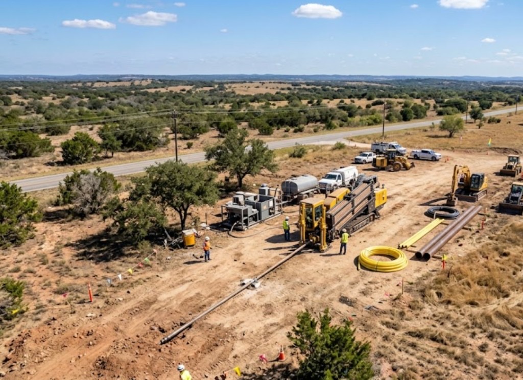
Sewer and water line boring in Mesa is the fix when a lateral fails under a gravel drive, sidewalk, or courtyard wall and the owner refuses full-yard restoration. Compact pits at the cleanout and city tap steer HDPE or PVC through caliche and compacted farmland fill without a continuous trench.
Dobson Ranch, Alta Mesa, and Las Sendas neighborhoods built from the 1970s through 1990s are hitting first sewer replacements — camera inspection confirms breaks under circular drives and courtyard pavers. Directional boring in Mesa for residential work spikes after Mesa Water notices and insurance-driven leak claims.
Municipal lead rehab along older Baseline and Main Street corridors sometimes bundles shallow laterals with main work — we coordinate tap rules, pressure test, and surface restoration per Mesa Water detail.
Real Maricopa County angles — not generic statewide copy.
Clay lateral collapsed under rock mulch — HDD from cleanout to tap preserves the drive open-cut would rebuild.
Post-monsoon heave cracked PVC under pavers — bore path avoids full drive removal; tie-in at meter may need a small access cut.
City notice on aging lead — trenchless pull keeps landscaped common areas intact; tap responsibility spelled out in quote.
Restaurant pad on Southern Avenue cannot lose stalls to trench — bore under asphalt with night tie-in to city main.
Mesa sewer and water bores begin with camera and locate confirmation — then pits sized for caliche stability. Pipe is pulled and tied per city tap rules; testing and restoration follow Mesa Water requirements. Monsoon-saturated farmland clay may delay pit work — we communicate when dry conditions matter.
Maricopa County Mesa parcels mix caliche hardpan, old farmland alluvium, and Red Mountain volcanic cobble — former citrus belt fill changes mud programs block to block.
Most Mesa bores hit caliche crust between 2 and 8 feet, then alluvial sand or compacted farmland fill depending on distance from Red Mountain. East Mesa and Gateway shots add volcanic cobble and fractured basalt that slow penetration without the right bit and mud program. Former citrus grove parcels can hide root mass and old concrete irrigation structures that potholing catches before pits are sized. Shallow groundwater along SRP laterals and desert washes raises buoyancy risk on long HDPE pulls — we size ream stages for East Valley fill, not a generic template.
East Valley heat, spring dust, and monsoon cloudbursts shape Mesa bore schedules — sheet-flow runoff through desert washes and afternoon lightning holds are planned into quotes.
Monsoon season from July through September softens farmland clay and can delay entry pits on former agricultural parcels. Spring dust on exposed east Mesa pads affects cage and fluid handling along Baseline and Ellsworth. Summer heat above 110°F slows morning startup on exposed sites but rarely stops work — we communicate when dry conditions matter for caliche-heavy pits rather than risk frac-outs toward SRP laterals.
City of Mesa Development Services, Maricopa County ROW, ADOT District, SRP canal easements, and Union Pacific rail agreements apply on many alignments.
Inside Mesa city limits, street cuts, driveway removals, and canal-adjacent work may need Development Services permits. Maricopa County ROW rules apply on unincorporated pockets toward Queen Creek fringe. ADOT controls US-60, Loop 202, and Loop 101 access ramps — MOT plans are common on Baseline frontage. SRP canal and lateral easements add coordination beyond standard 811. Union Pacific agreements govern rail crossings near the industrial belt.
Rock mulch, paver drives, and courtyard walls cost more to replace than a shallow trench in an empty lot — boring wins where restoration is the pain point. Wide-open rear easements on new Eastmark lots sometimes still favor trench on price.
Length, depth, tap fees, rock, paver restoration, and access for rig staging.
You share plans or describe the problem; we confirm alignment, depth, access, and which trenchless method fits Arizona soils.
Arizona 811 ticket filed; two business days minimum before pits open unless your permit path differs. We pothole where marks conflict.
Bore plan, ADOT or city ROW permits, railroad agreements, and crossing engineering when the path leaves private property.
Compact spread for tight Scottsdale lots; larger HDD for I-17 or Loop 101 relocations — matched to length and diameter.
Steered pilot on design line, ream passes sized for your pipe or casing, fluid program tuned for caliche or decomposed granite.
HDPE fusion, steel casing, or multi-duct bundle pulled with tension and bend-radius monitoring.
Pressure test, mandrel, or survey records for owners, inspectors, and operators as spec requires.
Compact pits, replace gravel or hardscape per scope, leave 811 ticket and locate map in your project file.
Often yes when alignment and tie-in points allow pits at logical ends — confirmed on site after camera and locate.
Varies by utility and address — quote states whether owner, city, or our crew coordinates the tap.
Many driveway shots finish in one to two days after valid locates. Rock, permits, or saturated clay extend the window.
Sometimes — alignment must clear pool plumbing and structural limits. Site walk determines feasibility.
24/7 — Emergency dispatch statewide. Tell us entry, exit, pipe size, and county — a bore specialist calls back with cost drivers, not a flat rate.
Scope your alignment
Step 1 of 2 — path, pipe, and city first