Trunk sewer under Old Town mixed-use fill
Deep gravity sewer with tight elevation — shaft footprints replace a continuous trench conflicting with shallow APS and fiber.
Peoria, AZ · Maricopa County
Microtunneling and pipe jacking for Peoria municipal trunk sewers — sealed-face mining when HDD cannot hold gravity grade in canal-adjacent fill.
Tunneling and TBM work in Peoria targets municipal trunk sewers, large storm outfalls, and owner specs where steerable HDD cannot meet gravity tolerance near Old Town and Lake Pleasant Parkway utility congestion. Shaft spreads localize disruption compared to open trenching a deep trunk through West Valley fill.
Agua Fria wash and regional drainage outfall projects often land here — high groundwater, flood review, and settlement limits push engineers toward pipe jacking instead of wide open cuts through trail systems.
Residential laterals and short commercial shots stay on HDD or auger bore. Microtunneling in Peoria is a municipal and large-contractor tool — we scope shafts, slurry handling, and city inspection milestones when your plans call for it.
Real Maricopa County angles — not generic statewide copy.
Deep gravity sewer with tight elevation — shaft footprints replace a continuous trench conflicting with shallow APS and fiber.
Flood review and bank stability favor mined crossings with engineered shafts instead of open cut through saturated alluvium.
RCP jacking on laser guidance with city mandrel inspection — settlement monitoring where adjacent hardscape cannot tolerate heave.
ADOT-adjacent storm trunk where lane closure math favors shaft-to-shaft mining over open cut across frontage roads.
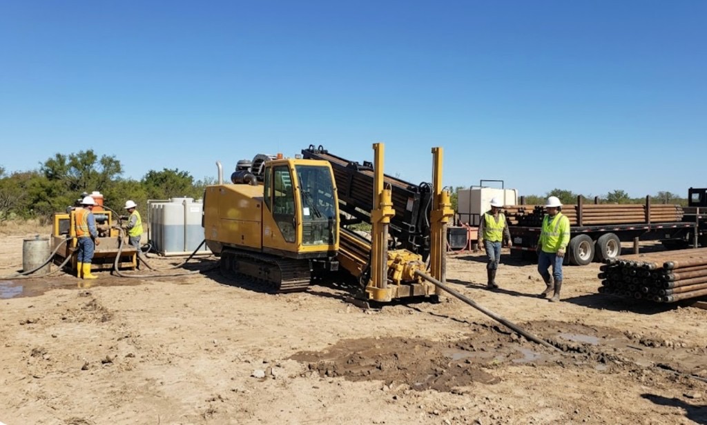
Microtunneling in Peoria begins with shored entry and reception shafts — dewatered and surveyed to city hold points. A steering head mines the face while pipe segments jack behind; slurry handling matches wash-adjacent groundwater. Laser guidance keeps grade for gravity sewer.
Peoria parcels mix caliche hardpan, Agua Fria alluvium, and master-planned grading fill — north Peoria boulder fields and Lake Pleasant fringe cobble slow pilots without matched mud programs.
Most Peoria bores hit caliche crust between 2 and 8 feet, then alluvial sand or compacted master-plan fill depending on parcel age. North Peoria and Lake Pleasant fringe shots add boulder fields and fractured granite fragments that slow penetration without correct tooling. Vistancia and Westwing grading can hide old irrigation structures that potholing catches before pits are sized. Shallow groundwater along SRP laterals and wash corridors raises buoyancy risk on long HDPE pulls — we size ream stages for Peoria fill, not a copy-paste Glendale template.
West Valley heat, spring dust, and monsoon outflows shape Peoria bore schedules — wash runoff from north Peoria foothills and afternoon lightning holds are planned into quotes.
Monsoon season from July through September softens wash-adjacent clay and can delay entry pits on north Peoria parcels. Spring dust on exposed Vistancia pads affects cage and fluid handling along Lake Pleasant Parkway. Summer heat above 110°F slows morning startup on exposed sites but rarely stops work — we communicate when dry conditions matter for caliche-heavy pits rather than risk frac-outs toward SRP laterals.
City of Peoria Development Services, Maricopa County ROW, ADOT District, SRP canal easements, and Lake Pleasant Regional Park coordination apply on many alignments.
Inside Peoria city limits, street cuts, driveway removals, and canal-adjacent work may need Development Services permits. Maricopa County ROW rules apply on unincorporated pockets toward the Lake Pleasant fringe. ADOT controls Loop 101, US-60, and state highway bores — expect traffic control plans and sometimes night-only windows on spring-training event calendars. SRP canal easements add coordination beyond standard 811. HOA and entertainment-district parcels may add landscape bond review on pit placement.
Open trenching a deep Peoria trunk through urban fill hits every shallow utility and storefront access issue. HDD rarely replaces microtunneling when diameter exceeds steerable tooling or grade tolerance is municipal-gravity strict.
Diameter, length, shaft depth, groundwater handling, disposal, guidance, and municipal inspection milestones.
You share plans or describe the problem; we confirm alignment, depth, access, and which trenchless method fits Arizona soils.
Arizona 811 ticket filed; two business days minimum before pits open unless your permit path differs. We pothole where marks conflict.
Bore plan, ADOT or city ROW permits, railroad agreements, and crossing engineering when the path leaves private property.
Compact spread for tight Scottsdale lots; larger HDD for I-17 or Loop 101 relocations — matched to length and diameter.
Steered pilot on design line, ream passes sized for your pipe or casing, fluid program tuned for caliche or decomposed granite.
HDPE fusion, steel casing, or multi-duct bundle pulled with tension and bend-radius monitoring.
Pressure test, mandrel, or survey records for owners, inspectors, and operators as spec requires.
Compact pits, replace gravel or hardscape per scope, leave 811 ticket and locate map in your project file.
Large-diameter gravity sewer, tight grade tolerance, or sealed-face mining specs. Your engineer's method note drives the answer.
Shafts are smaller than a full trunk trench but still need traffic control and restoration — localized impact, not zero surface work.
We coordinate with your engineer for shaft, mining, and reception hold points per contract — city inspectors witness per detail.
Rarely — short laterals use HDD. Trunk and interceptor scale justifies shaft spreads.
24/7 — Emergency dispatch statewide. Tell us entry, exit, pipe size, and county — a bore specialist calls back with cost drivers, not a flat rate.
Scope your alignment
Step 1 of 2 — path, pipe, and city first