Channel bank casing near Bridgewater Channel
Marina district template with welded inspection — drive pit dewatering and bank stability holds scoped upfront.
Lake Havasu City, AZ · Mohave County
Jack and bore casing on Lake Havasu channel structures and highway approaches — straight steel pushes when marina templates and ADOT specs require rigid carrier protection.
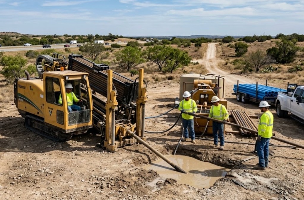
Auger boring in Lake Havasu City fits Bridgewater Channel bank structures, storm outfalls toward the Colorado River, and straight runs under Highway 95 approach slabs where casing grade matters more than steerable flexibility. Shored and dewatered pits handle running sand sidewalls and channel-adjacent groundwater.
Directional boring in Lake Havasu handles curves and long HDPE on residential laterals; jack and bore wins when the engineer specifies welded casing under highway approach or channel crossing on a line-and-grade push. London Bridge area bank structures favor cased crossings over open cut through flood-control fill.
Running sand without dewatering can stall jack progress — test pits on channel-bank parcels reduce mid-job surprises before casing is ordered.
Real Mohave County angles — not generic statewide copy.
Marina district template with welded inspection — drive pit dewatering and bank stability holds scoped upfront.
Straight RCP push where slope stability blocks open cut — groundwater and flood-control holds scoped upfront.
Short rigid carrier under mixed-use hardscape — grade control on a 55-foot push beats HDD tolerance on some ADOT details.
City detail with internal dividers for telecom and electric — jack sets shell before internal pulls.
Lake Havasu auger bore starts with pit layout on survey line — locates cleared, shoring and dewatering for sandy sidewalls, groundwater control when channel-adjacent water enters the drive pit. Casing advances on line and grade; marina district or ADOT inspection follows owner templates.
Lake Havasu City soils are Colorado River alluvium, decomposed granite, and compacted lakefront fill — high water table near the channel and river banks demands dewatering discipline absent on inland caliche jobs.
Most Lake Havasu City bores hit loose Colorado River sand and decomposed granite in the first few feet, then compacted lakefront grading or basalt cobble depending on parcel elevation. Channel-adjacent and river-bank shots carry high groundwater that collapses uncased entry pits without dewatering. Havasu Riviera master-plan fill can hide old marina drainage structures that potholing catches before pits are sized. We size ream stages for river alluvium and water table, not an inland Phoenix caliche template.
Lake Havasu's desert heat and summer monsoon surges shape bore schedules — Colorado River humidity pockets and afternoon lightning holds are planned into quotes.
Monsoon season from July through September raises groundwater near the Colorado River and can delay entry pits on channel-adjacent parcels. Spring break and summer boat-traffic season stacks tourist traffic on McCulloch Boulevard and lakefront corridors — bore schedules account for peak windows. Summer heat above 115°F slows afternoon startup on exposed sites but rarely stops work — we communicate when dry sand conditions matter for long pulls rather than risk frac-outs toward shallow gas mains.
City of Lake Havasu City Development Services, Mohave County ROW, ADOT District, Colorado River floodway coordination, and marina-district easements apply on many alignments.
Inside Lake Havasu City limits, street cuts, driveway removals, and channel-adjacent work may need Development Services permits. Mohave County ROW rules apply on unincorporated pockets toward Desert Hills. ADOT controls Highway 95 and state highway bores — expect traffic control plans and sometimes night-only windows on tourist-season corridors. Colorado River floodway easements add coordination beyond standard 811. Marina and lakefront parcels may add landscape bond and flood review on pit placement.
Jack and bore preserves highway pavement and channel bank width on short straight obstacles. Curved sewer without casing shifts to HDD. Open-cut across Bridgewater Channel banks is rarely permitted versus cased templates.
Casing size, drive length, pit depth, groundwater, rail or highway flagging, and welding inspection.
You share plans or describe the problem; we confirm alignment, depth, access, and which trenchless method fits Arizona soils.
Arizona 811 ticket filed; two business days minimum before pits open unless your permit path differs. We pothole where marks conflict.
Bore plan, ADOT or city ROW permits, railroad agreements, and crossing engineering when the path leaves private property.
Compact spread for tight Scottsdale lots; larger HDD for I-17 or Loop 101 relocations — matched to length and diameter.
Steered pilot on design line, ream passes sized for your pipe or casing, fluid program tuned for caliche or decomposed granite.
HDPE fusion, steel casing, or multi-duct bundle pulled with tension and bend-radius monitoring.
Pressure test, mandrel, or survey records for owners, inspectors, and operators as spec requires.
Compact pits, replace gravel or hardscape per scope, leave 811 ticket and locate map in your project file.
Casing templates and straight alignments favor auger bore. Curved HDPE paths favor HDD. We review the engineer method note before quoting.
Physical jacking may finish in days; marina district agreements and inspection holds often drive lead time beyond jack duration. Quote includes easement scope.
Running sand and channel-bank groundwater without dewatering can stall progress. Test pits reduce surprises near Colorado River alluvium.
Yes when plans specify casing and gravity grade on a straight push. Large trunks may need microtunneling.
24/7 — Emergency dispatch statewide. Tell us entry, exit, pipe size, and county — a bore specialist calls back with cost drivers, not a flat rate.
Scope your alignment
Step 1 of 2 — path, pipe, and city first